There are many terrific benefits of drones across multiple sectors. Every week, we read about the new benefits of using UAVs for inspections.
Drones being used in sectors, such as science, agriculture, construction, marketing, archaeology, conservation, the environment. Drones are benefiting search and rescue missions immensely.
They are saving lives, time and money. A couple of years ago, you would only see drone scenery videos on the Internet with very few news items about drones in other sectors. Not any more.
Drone innovation and technology have improved immensely. Combining improved drone technology with existing technology (cameras, infrared, sensors, 3D mapping and software) has given Researchers, Scientists, Universities and Business new avenues for their use.
The drive to seek better solutions to problems is perhaps the main reason why drones are becoming so popular.
There really are so many benefits of drones across all sectors to solve real world problems. The list of drone uses is growing all the time. Lets take a look at these benefits in the various sectors to date saving lives, time and money.
Terrific Benefits Of Drones
Drones Assist With Tornado Warnings
Researchers in Oklahoma are working with drones to measure the lower atmosphere so they can produce earlier warnings before severe weather strikes. The Oklahoma Researchers are expecting weather drones to help forecasters predict patterns more precisely allowing tornado warnings to be given anywhere from 20 to 60 minutes earlier.
Presently, meteorologists use radar, satellites and balloons to check conditions in the upper and middle atmosphere. Conditions at the lower atmosphere where we live are observed by instruments and people which puts their lives at risk.
In the future, small unmanned aircraft will be widely used to measure the lower atmosphere giving better weather predictions and earlier warnings.
Drones Assist Fire Departments
Drone assisting fire fighting crews will save lives, time and money. Here are a number of ways drones are being used presently along with research into more ways drones can assist Fire and Rescue Departments.
1) Underground Fires: Fire crews have to stay at a site for a long time after the initial fire has been put out. This is because the radiant heat in soil or underground can burn at hundreds of degrees Celsius, smoldering away.
Using drones with infrared sensors and flying over the fire zone, the crew can work out the precise heat underground and know when they can leave. This technology can be used by both City and National Park fire crews.
2) Building & House Fires: Lots of fire departments have already invested in UAVs with high definition cameras. Fire crews benefit immensely from the reconnaissance a drone provides.
The drone can fly and hover at the height of a building or well above it. The drone high definition camera is capable of sending still shots and live video to crews on the ground, so they don’t have to guess where to target the blaze.
Drones assist fire crews to more accurately gauge the structural stability of a burning building, allowing firefighters to escape before a potential collapse.
3) Surveying a Hazardous Material Accident: Using a drone over an accident area to send aerial photos and video allow a fire crew to tackle the accident using the right equipment and use their resources and manpower more efficiently.
 4) Assisting Fire Crews After Storms: Drones are now being used to survey disaster areas saving fire departments time and man power.
After a snow storm or a hurricane, fire crews are flat out busy. They’re rescuing people, putting out fires and at the same time pumping water from other places.
They have to survey a whole devastated area. Helicopters are not always available. Helicopters are expensive so most fire departments may not have one at their disposal. Drones will fill this gap tremendously.
Drones Locate Landmines In Laos
Ryan Baker, CEO of aerial imaging firm Arch Aerial, hopes his company will be able to deploy their drones to map out mine fields and locations littered with unexploded bombs from historical warfare.
 Baker suggested that his company wants to start the program in Laos, the world’s most heavily bombed country during the Vietnam War, where the nation was targeted in over half a million campaigns, which dropped over two million tonnes of bombs across Laos.
Laotians are still suffering the effects of a land riddled with landmines and unexploded cluster bombs. Ten of Laos’ 18 provinces have been labelled “severely contaminated”, with ‘tennis ball-size’ cluster bombs being the biggest threat.
In Laos “there have been some 12,000 accidents related to UXO [unexploded ordnance] since 1973,” said Baker. He added that most of these deaths and injuries occurred during bomb disposal or when farmers are plowing their land.
Baker said that the octocopter technology will work using a remote laser imaging platform called LiDAR to analyse fields and identify sites, where UXO is likely to be uncovered. LiDar sensors are crucial systems in the design, as it can easily see through vegetation and creates detailed maps of the terrain, even in Laos’ densely vegetated forests.
Surveyors will be able to use the maps to look for topographical signs which suggest past bombing activity, surrounding trenches and bunkers for example.
Baker added that the program was only possible thanks to great advancements in lidar technology: “A few years ago, a lidar system was the size of a kitchen table and had to be fitted into a gutted airplane,” which required a lot of funding and compliance with local flight rules and regulations.
He continued to confirm that Arch Aerial will start testing the drones this year in collaboration with a humanitarian NGO working on UXO in Laos.
3D Images Of Monuments And Buildings
Creating precise 3D imaging of large monuments, sculptures and even buildings is a growing sector where drones are been used. They can be used in films, gaming and modelling. Combined with 3D printing, accurate smaller models can be recreated.
Mapping Christ the Redeemer
On 18th February 2015, Pix4D, Aeryon Labs and PUC University of Rio de Janeiro, announced the first accurate 3D model of Brazil’s most important monument: the Christ the Redeemer statue in Rio de Janeiro.
Using an Aeryon Scout quadrotor for data acquisition and Pix4D’s image processing software for the 3D reconstruction, the project team overcame various challenges to acquire the high-resolution images needed for the model.
There are loads of photogrammetry solutions on the market for creating 3D maps of lands and structures. You can read on these software solutions in this article entitled “Best Photogrammetry Software For 3D Mapping“. This article includes all information how 3D mapping works and includes excellent videos.
Ecological Drones
The use of drones for environmental and ecological applications is vast. Drones will be used widely in the surveying of land and coastal regions for erosion. With high definition digital cameras and specialized software, it is possible to produce geo-referenced orthomosaics of any landscape or building. This process creates a single image by “stitching” images together.
Water Sampling Drones: The traditional way of water sampling involves hauling equipment, boats and people to sites, sometimes hundreds of miles away.
Sending UAVs to fly over the water, dip a hose and pump samples into collection tubes saves time and money. It improves data collection by enabling scientists to sample inaccessible areas or to improve timing, such as collecting multiple samples at once or immediately after a rainstorm.
Drone prototypes which are able to scoop up water samples are being developed to help ecologists and industry to track oil leaks, pollution or invasive species in our ponds, rivers and lakes. Some drones can even perform simple analysis using a spectrometer on the water they collect.
Precision Hawk in North Carolina, is testing a water sampling drone with some clients in the oil industry. The water is sucked into a container on the drone and then carried to a lab to check for signs of oil leaks or spills.
Researchers at the University of California are testing a quadcopter with a floating frame which lands on water to collect samples to be flown back to a lab for DNA extraction and sequencing.
Their goal is to collect what is called environmental DNA, or eDNA, left behind by plants, animals, or other organisms. Analyzing eDNA provides a way to track diseases and endangered or invasive species.
Here is a video showing the University of Nebraska-Lincoln which are developing unmanned aerial vehicles which interact with the environment to collect water samples.
Drones In Archaeology
 From surveying archaeology sites to finding ancient civilizations, drones will play a big role into the future.
In Peru, they are using small UAVs with cameras to map ancient sites and preserve these sites. What would normally take 3 months can be completed in less than 1 week.
Archaeologists have known since the 1970’s that aerial images of infrared wavelengths can be very useful for surveying areas covered by vegetation or soil.
However, this could be accomplished using satellites or helicopters, which is expensive and has limitations. The only other way to identify buried structures is by digging a large number of test pits, which is time-consuming and requires a lot of effort.
Using an UAV, with a thermal imaging camera, researchers can detect archaeological features buried up to a half a meter below the surface of the ground. Images are collated using advanced photogrammetry methods, producing accurate thermal maps of the archaeological area.
Ancient Civilizations: Researchers from the University of Exeter in the UK are searching for evidence of ancient lost civilizations using drones in the Amazon jungle, hoping they may be able to learn how large those communities were and how much they altered the landscape.
The scientists explained how they are developing a remote sensing data device to be attached to a UAV in order to scan beneath the forest’s canopy.
The project will be searching for ruins which were constructed up to 1000 years ago. With the data they collect, it is expected to help guide modern day policy on sustainable forest use.
Drones Seek Out Ancient Ruins
A top quality drone can capture pictures and video from a constant altitude. This allows for the production of a photographic map of the entire dig site including measuring distances and angles between objects.
Using software, operations such as computing areas and lengths along curves can be calculated without resorting to complicated surveying methods. The images obtained can also be used to create a stereoscopic projection, allowing viewers to see more detail and perceive depth directly.
To locate ancient ruins a UAV can be fitted with thermal cameras. Over the course of a day and a night, different parts of a landscape heat up and cool down at different rates. Buried stones, for example, tend to retain heat longer than the surrounding dry soil. This means that in the early morning, the stones will be much warmer than the surrounding earth.
Those temperature differences are invisible to our eyes, but a thermal camera, which detects infrared light (heat), can easily record and reveal them. If the buried stones happen to be the remains of ancient buildings, the camera has just taken a picture of a lost settlement without digging a single hole. Drones have already been used to reveal a 1,000 year old village in New Mexico.
This video shows the use of standard UAVs by Archaeologists in Peru. They are using a DJI Phantom 3 and a DJI Spreading Wings drone.
Drones In Conservation
One of the areas where drones are already making a big impact is in wildlife conservation. Some of our most beautiful animals are at a serious risk of extinction from poachers. Rhinos, Elephants, Tigers and Orangutan are commonly shot and shipped illegally for their tusks, skins and other body parts.
In South Africa up to 2007, about 14 Rhinos were killed each year. From 2007 onward, the killing of rhinos increased dramatically with 1250 killed in 2014. Other countries in Africa have also see a huge rise in the killing of Rhinos and Elephants.
With the horrific loss of these magnificent animals, a country which allows this to happen loses it’s spirit along with the economic benefits of tourism. Visit the website of Conservation Drones to read some terrific stories on how this sectors is using drones for good.
These lightweight anti poaching conservation UAVs can track animals in their natural habitat, monitor the health of rain forests, even combat crime by detecting poachers via thermal imaging. Drones are affordable which should allow for more wide spread use by National Park Rangers.
In the below video, ecologist Lian Pin Koh shows how using drones can protect our world’s forests and wildlife.
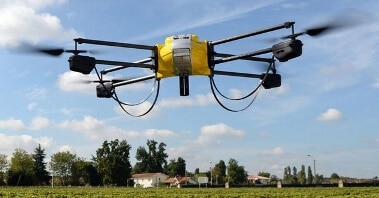
Drones In Agriculture
The use of drones in agriculture is growing every week. Drones are been used for simple but time consuming tasks of surveying farm buildings and fencing; searching for lost sheep and cattle; inspecting land after storms and also checking for flooding or irrigation hosing for leaks.
With multispectral sensor imaging drones, then the health of soil and plants can be monitored. A multispectral sensor can also be used for early detection of pest and fungal infestations which can’t be seen at eye level.
Drones in agriculture are been used to create 3D photogrammetry maps of the land. These drones can be either miniature fixed-wing airplanes or quadcopters. Quadcopters such as the DJI Phantom, Inspire 1, Solo are very popular. The senseFly eBee for agriculture is also very popular and it has multiple sensors on board.
These UAVs can fly on autopilot using GPS and along with a standard point-and-shoot camera or an infrared camera, they can take photos every 1 or 2 seconds.
Specialized software such as the Pix4DMapper can stitch these aerial shots into a high-resolution 3D photogrammetry and mosaic maps.
The below video shows you how 1 farmer is using a drone to survey his crops.
Benefits Of Drones In Various Sectors
Drones In Mining & Logging
Drones are great at doing big jobs very quickly. Mining and Logging companies will always have large stockpiles of materials. This is inventory and money tied up in stockpiles. Using a Time-of-Flight camera sensor on a drone, the stock pile can volume can be measured.
ToF cameras sensors along with it’s software can measure stone, gravel, rock, pulp, paper, logs, wood chip, mulch and manure etc. Here’s an example of a Kespry 2 drone measuring stockpiles.
You can read more in this article on Time-of-Flight cameras for drones. These ToF sensors have terrific uses including object scanning, indoor navigation, obstacle avoidance, gesture recognition, tracking objects, measuring volumes, reactive altimeters, 3D photography, augmented reality games and much more.
Wildlife Photography
Birds and other wildlife tend to perch on tall trees and buildings, making them a challenge to photograph. Even using an expensive telephoto lens can make getting great pictures and video extremely difficult.
Drones use electric power and brushless motors to reduce noise levels. This allows the drone operator to fly close to wildlife without disturbing them giving the opportunity to capture amazing aerial pictures and video.
The latest UAVs can circle around an object while the camera keeps the object in view and photographing at all times. Drones can also hover in place which allows for more opportunities to concentrate on the camera.
With a live feed and remote zoom, tilt and shutter controls, there is no reason why anyone can’t get amazing wildlife videos from any position.
Along with wildlife and beautiful scenery, there is over 1000 UNESCO World Heritage sites and very few have been filmed from the air. I have no doubt that tourism boards and hotels would pay a small fortune for great drone videos of UNESCO sites.
Here is an example of some excellent nature and wildlife videos from AirVuz. They sure know how to film mother nature.
Drone Use In Advertising Sector
Promoters and advertisers are always looking to maximize their return on investment. A few years ago, if they wanted aerial pictures or video for promotions, they would have to hire a full size helicopter and pilot along with a film crew.
Helicopter rentals are extremely expensive. This adds a large overhead cost which increases the initial investment and decreases the return on investment.
Instead of hiring a full size helicopter and film crew every time they need aerial pictures and video, advertisers will now look to use drones for marketing which will save both time and money.
News Media Aerial Filming
The drone is the ultimate news media and reporting tool. Live aerial streaming of video is what News Networks love. The use of drones in collecting media stories is called drone journalism. With a quality drone and camera, journalists and news reporters will be guaranteed to have a pristine, interference free video of any event where aerial filming is required.
Top quality drones are very stable. The latest top drones have advanced flight controllers which hold the drone in position allowing for the best quality of video. You can remotely control the pan, tilt, and zoom of the drone to get the best possible aerial view at all times.
 Professional Aerial Photography

If you’re a freelance professional photographer or own a photography business, then a top quality drone represents the ultimate aerial photography platform.
You can take amazing pictures for clients from angles and positions that you couldn’t access otherwise.
Drones allow you to get great aerial pictures, which capture large areas, horizons, bodies of water and other objects of artistic interest to photographers.
Live feed capabilities allow you to show clients exactly what the helicopter is seeing at all times. This helps ensure that customers get exactly the aerial pictures and video they want.
The latest drones have the best drone and camera stabilization systems. They also have intelligent modes, which allow the drone to fly, photography and film autonomously. If you are a new to drones and photography, then these 15 aerial photography tips are great to know. Some of the tips are easy to implement while others will take some practice.
Benefit Of Drones To Hotel And Golf Resorts
Drones are perfect for aerial photography and cinematography of Hotels and Golf Resorts. Drones can carry top of the range cameras to heights sufficient to capture stunning aerial pictures and video of any golf resort or hotel. Drones are ideally suited to aerial photography and filming projects.
For example, using drones for Golf Course flyovers, the following information can be gained;
- Assist golfers in understanding the golf course and planning their game
- Find maintenance issues and identify problems before they cost money in lost clients and investors
- Promote the golf course or resort with professional quality, birds eye view pictures and video
- Monitor the progress of construction and improvement projects to the golf course
- Using multispectral remote sensing drones, grass, flowers, shrubs and trees health can be monitored
Real Estate Drones
Using drones for real-estate advertisement is capture outstanding aerial pictures which can provide clients with a much more complete picture of the property.
Aerial pictures and video can be used on websites, printable brochures or almost any other advertising media imaginable.
Construction Project Drones
Large projects such as bridges, roadways and pipelines require hundreds of workers to complete. Construction workers, foremen, managers and engineers have to work in unity to complete large projects on time and under budget. Getting an accurate picture of a construction site can be difficult with large projects. UAVs are the solution.
Construction projects are getting larger and more ambitious. A quality drone can keep up with the massive influx of information which construction project managers and engineers face every day to ensure the project’s success.
Industrial construction projects build the facilities needed to make everyday life possible for society. Industrial construction projects can include, but are not limited to:
- Medical buildings and facilities including hospitals, research units, labs and associated infrastructure
- Power plants, transformers and distribution centers
- Petroleum refineries, pipelines and distribution centers
- Chemical refineries
- Manufacturing plants for products such as vehicles, houses, and other everyday products
Although Industrial construction projects make up a relatively small percentage of the total construction; they are some of the most complex projects to manage.
Industrial construction projects require the constant interaction of employees from different disciplines, including engineers, managers and construction workers. With all the free variables a large industrial project creates, getting an up to date and accurate picture of the projects progress can be extremely difficult.
Already, UAVs with lidar sensors are already being widely used on all large construction sites within the next few years.
- Corridor mapping: power line, railway track, and pipeline inspection
- Construction site monitoring
- Building and structural inspections
- Surveying of urban environments
- Resource management
- Hydrodynamic modeling
- Digital Elevation Models
Drones Inspect Masts And Buildings
The old way of inspecting flare stacks (below video) was to shut down production and take the stacks down. Using drones to get close to the flare stacks allows companies to see detailed images of the structure and flare tips.
Saving Lives: The 2nd video below shows you a very tall TV tower. Both TV and Telecoms masts have to be inspected for structural integrity every year.
In the Netherlands a report was released showing that they were over 100 deaths just from inspecting Telecoms masts over a 5 year period. Using drones instead of workers to climb these masts for inspection will save a lot of lives and prevent injuries to workers.
How many injuries and lives are lost every year when scaffolding collapses or someone falls off while inspecting a building or roof. Probably thousands worldwide.
Inspecting buildings or masts by erecting scaffolding or arranging for a climber to scale up high rise masts is costly, time consuming and hazardous.
Using drones will prevent injury, save lives and time. Hopefully this will also allow companies to follow through with more regular inspections.
Drones For Surveying Pipelines
Thousands of miles of power, water, natural gas and other utility lines run across every country. Modern society depends on these utilities for everyday activities, and interruptions can have very serious consequences. Because of this, inspections of remote utility lines are carried out regularly.
A quality drone allows for flying above potentially damaged utility lines and bringing back crystal clear aerial pictures and video for inspection.
Drones For Highway Maintenance
Economics and society depend heavily on efficient and well maintained roads. Trucks transport over 70 percent of goods in the United States alone, including food, consumer products, medical supplies and other necessities for everyday life. Drone use for road inspection will become very popular.
Roads degrade with time, and require constant maintenance to keep moving. Drones such as the Mavic 2, Mavic 2 Zoom, Phantom 4 Pro V2, DJI Inspire 1, DJI Inspire 2 and Yuneec Typhoon H can obtain high quality aerial pictures and video of road surfaces, so that engineers, construction workers, and project managers can get an accurate picture of road conditions.
Surface defects such as pot holes, cracks and abrasions can be easily seen with a high resolution aerial picture, allowing a team to take corrective action before the road has to be torn up and replaced.
There is no doubt that drones, quadcopters and multirotors will play a huge part in our lives from now on in. I don’t know if they will ever deliver parcels and letters to our door steps. But from this article we can already see the tremendous benefits and impact small UAVs are having even though the technology is still quite young.