What Is FPV Camera Technology In Drones And Best Uses

What Is FPV Camera Technology In Drones Answered

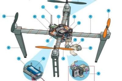
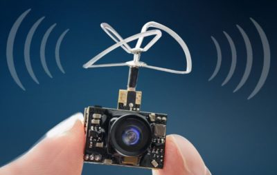
FPV cameras are small, light and reasonably priced.  The FPV camera is mounted onto a drone to send real time video down to the ground using a video transmitter.  The FPV camera allows you to see where the drone is flying and what it is seeing as if it had its own eyes.

Depending on the drone, the FPV transmitter will send the live video signal to your Remote Control screen, monitor, smartphone device, tablet or FPV goggles.

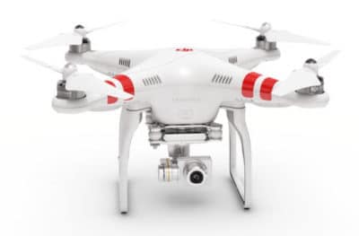
FPV cameras like the one you find on the DJI FPV allow you to fly higher and further with some of latest drones being able to fly up to 5 miles away using FPV technology.  Military drones or large high-end drones can fly thousands of miles using FPV technology.

This post answers the question of what is FPV camera systems and technologies.  Here we explain the latest FPV camera technology on small consumer, commercial and FPV racing drones including CMOS or CCD imaging sensors, Fields Of View (FOV), TVL, Dynamic Range and much more.

When you understand FPV camera technology in drones, then you have the knowledge to make changes and expand the distance of the FPV live video.  Another terrific article for you to read is entitled “Extending Drone Live Video, Gain And Range” which discusses further on how antennas, transmitters and receivers work.

Read more

How Do Drones Work And What Is Drone Technology

Drone technology used in various popular Quadcopters

What is a drone and how do drones work is answered here in this easy to understand article. UAV drone technology is constantly evolving as new innovation and big investment are bringing more advanced drones to the market every few months.

Below, we discuss UAV technology on the most popular drones on the market, which have all the latest drone technology.  Most UAV drones will have very similar systems incorporated.

Also included is the latest list of top drones with cameras on the market right now.

Unmanned aerial vehicle technology covers everything from the aerodynamics of the drone, materials in the manufacture of the physical UAV, to the circuit boards, chipset and software, which are the brains of the drone.

Read more

Quick Drone Parts Overview Along With Handy DIY Tips

Drone Parts And Components Guide

All drone parts and components are vital to a smooth and safe flight. Knowing the parts of a drone will give you extra confidence while flying. You will also know which components to inspect on a regular basis and the drone parts which are easy to replace or upgrade.

If you have any flight problems, then knowing what each drone component does will assist you greatly in getting to the bottom of any flying issues.

This article will provide you with a great overview of all the drone parts and components which you will find on a modern day consumer and professional drone.

Read more

How To Secure Your Drone From Hackers Permanently

Tip and Information To Secure Drone From Hackers

Imagine your drone being hacked into and stolen while in mid flight. Your drone just starts to fly away from you. After you run to see where it has gone, your cannot find it. It has just disappeared.

Or just as bad, you lose control of your drone and it crashes.  You blame your piloting skills or electric interference from a telephone mast. But the problem is, your drone has been hacked into.

Drones are very much like flying computers.  They have operating systems, network connections and hardware which all have programmed code.  So in many ways a drone is just as easy to hack into as a computer.

Someone that can hack into a computer can hack into a drone.  They just have to make the connection to either your remote controller (cellphone, tablet, laptop) or to the drone by intercepting the signal.  But there are ways you can secure your drone from hackers.

Read more

12 Top Lidar Sensors For UAVs, Best Lidar Drones And Great Uses

7 Top Lidar Sensors For Drones

Lidar sensors on UAVs capture imagery which only a few years ago needed an aircraft carrying large heavy lidar sensors and a crew to accomplish.

Here, we look at 12 of the best lidar sensors for drones along with the best lidar drones.

We feature lidar sensors from manufacturers such as Velodyne, Routescene, Leddartech, Riegl, YellowScan, Leica and Geodetics.

The lidar drones include quadcopters, fixed wing drones, UAV helicopters from manufacturers such as DJI, Harris, Velos, Vulcan, OnyxStar and many more.

A lidar sensor mounted on a UAV, along with the lidar software can process images very quickly in the cloud, allowing for effective decisions to be made by stakeholders and relevant parties.

The output from these lidar drones and sensors is outstanding.  The pace of development and improvement in the lidar sensors over the past few years has been tremendous and will continue with more entrants into this sector.

Over the coming years, we are going to see most of the lidar sensor work moving from aircraft to lidar drones.

In fact, all the manufacturers of the large lidar sensors for airplanes have developed smaller lidar sensors for drones.

We start off this post with the lidar drones being used for the various sensors, followed by how lidar sensor technology works. Then, we look at the best lidar sensors for drones.  Along the way, we have some terrific lidar drone sensor videos.

Read more

Multispectral Imaging Camera Drones In Farming Yield Big Benefits

Multispectral imaging agriculture drones with sensors

Multispectral imaging camera sensors on agricultural drones allow the farmer to manage crops, soil, fertilizing and irrigation more effectively.

There are huge benefits both to the farmer and to the wider environment by minimizing the use of sprays, fertilizers, wastage of water and at the same time increasing the yield from crops.

Multispectral camera remote sensing imaging technology use Green, Red, Red-Edge and Near Infrared wavebands to capture both visible and invisible images of crops and vegetation.

The multispectral images integrate with specialized agriculture software which output the information into meaningful data.

This land telemetry, soil and crop data allow the  grower to monitor, plan and manage the farm more effectively saving time and money along with reducing the use of pesticides. 

Read more