UAV lidar and photogrammetry imaging applications are increasing rapidly. This is not surprising as using GPS enabled UAVs for aerial surveying is very cost effective in comparison to hiring an aircraft with photogrammetry equipment.
Because UAVs are relatively inexpensive, organisations will have their own UAV fleet, allowing for rapid surveys over large land areas and infrastructure projects where required.
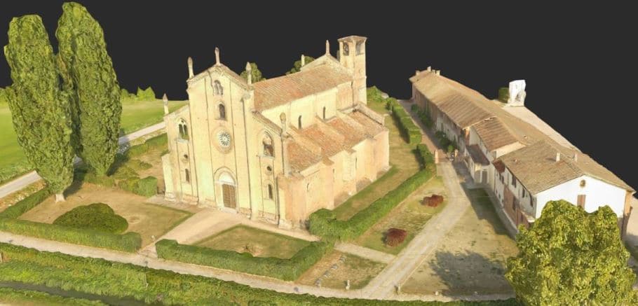
With GPS equipped drones, digital cameras and powerful computers, surveys have an accuracy right down to 1 centimeter.
This post takes an overall look at this drone mapping technology. We also take a quick view at the sectors benefiting from using UAVs for photogrammetry and lidar mapping. We also look at some of the best mapping drones on the market along with the compatible software.
Another closely related sector is using LiDAR sensors mounted onto drones. It’s another growing sector and you can read further regarding drone LiDAR use here.
The use of quadcopters and multirotors in photogrammetry and lidar mapping is still in the very early stages but growing very fast. There are terrific opportunities in various sectors. Now is the best time to learn about UAVs, photogrammetry, 3D and lidar mapping.
If you are interested in pursuing a UAV photogrammetry business or similar, buy the best quadcopter and sensors you can. There is tremendous opportunities for owners with quality UAV lidar and photogrammetry equipment.
What Exactly Is UAV Photogrammetry
Photogrammetry is the science of making measurements from photographs. The output from photogrammetry is typically a map, a drawing or a 3D model of some real world object or land mass.
3D Maps And Models
To create 3D maps from aerial photogrammetry, the camera is mounted on the drone and is usually pointed vertically towards the ground.
Using photogrammetry to create 3D models of monuments or statues, the camera is mounted horizontally on the UAV.
Multiple overlapping photos (80 to 90% overlap) of the ground or model are taken as the UAV flies along an autonomous programmed flight path called a waypoint.
To overlap photos of an object or land by 80 to 90% would be impossible to complete accurately by pilot navigation. It is essential to have a UAV which has waypoint navigation technology.
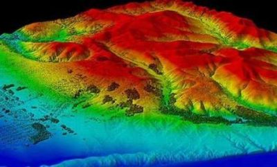
Drone Mapping And Lidar Explained
UAV lidar involves mounting a laser scanner on a UAV to measure the height of points in the landscape below the UAV. Lidar actually means (Light Detection And Ranging). 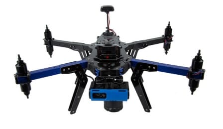
Lidar scanners can capture hundreds of square kilometers in a single day.
By measuring 10 to 80 points per square meter, a very detailed digital model of a landscape can be created.
The accuracy of the measurements, allow the 3D models created using the lidar drone to be used in planning, design and decision making processes across various sectors.
Lidar sensors can also pierce dense canopy and vegetation, making it possible to capture bare earth structure which satellites cannot see, as well as ground cover in enough detail to allow vegetation categorization and change monitoring.
Photogrammetry And Lidar Uses
Through the use UAV photogrammetry and lidar mapping, there is a large range of products, which can be extracted from the aerial imagery. These products include;
- DEM / DTM / DSM (surface models)
- Orthophoto’s (geospatially corrected aerial images)
- 3D building models
- Contour maps
- Planemetric features (road edges, heights, signs, building footprints, etc)
- Volumetric surveys
Here are some of the best uses of lidar and photogrammetry. All of these sectors benefit for having precision 3D images of their projects. They also benefit with increased efficiency and reduced costs than using traditional aircraft.
- Forestry management and planning
- Flood modelling
- Pollution modelling
- Mapping and cartography
- Urban planning
- Coastline management
- Transport planning
- Oil and gas exploration
- Quarries and minerals (Volumetrics and Exploration)
- Archaeology
- Cellular network planning
Lidar Uses and Drones
Here is a very specific article which covers all the uses of lidar sensors and best Lidar UAVs.
3D Vegetation Modelling
NOTE: Vegetation Modelling use multispectral sensors and lidar sensors rather than photogrammetry sensors.
Cameras For Photogrammetry And Drone 3D Mapping
There are several drones with cameras, which are ready made for 3D Mapping. In reality, any drone equipped with an intervalometer on the camera would be suitable. An intervalometer triggers the camera shutter. A minimum photo capture would be 1 photo every every 2 seconds. The below cameras all work well for photogrammetry and mapping.
- Canon Cameras – S110, SX260.
- Sony Cameras – QX1,DSC-RX100 A7R, A7, A7S, NEX-6, NEX-5R, NEX-5T, A5100.
- Panasonic Cameras – GH3.
GoPro camera lenses are not great for creating aerial maps. To get some sort of decent results, you would have to be flying higher than 400 feet (approx 120 meters).
Also, the integrated cameras on the DJI drones such as the Phantom 3, Phantom 4 and Inspire 1 will allow you to capture photogrammetry images. More information below on DJI.
Photogrammetry Best Practice
If photos aren’t good, then it’s going to be difficult to get real quality in your 3D models, no matter how good the software is. The photos should be as clear as possible. If you have drone with a zoom camera and you zoom in on your aerial photos, are the small features blurry. If so, try to figure out the reason for the blur and your 3D images will improve immensely.
Eliminate everything standing in the way of maximum sharpness. This is where more megapixels actually matters. Shooting in RAW definitely helps.
Lighting is always important in photography. Bright, even lighting will allow you to have a small aperture to reduce the image’s depth of field. Shallow depth-of-field is actually a bad thing for photogrammetry, because blurred details confuse the software.
The goal is to have high detail, sharp, and flat imagery which requires closing up the aperture, giving more light. Good lighting will also allow you to lower the ISO, which will reduce grain, and it will allow you to have a high shutter speed which also reduces motion blur.
Give the 3D photogrammetry software only high resolution information. If you are mapping a sculpture or building and don’t need the background, then mask it out.
If one image is off or not aligning correctly with the images before and after it, then delete this image. Humans are still smarter than software, which will be stitching the images together. Filtering out bad or off line photos before the software gets to work, will make the work of the 3D photogrammetry software easier giving higher image accuracy.
If its not in the picture, then it’s not in your mesh and 3D image. Make sure you have the coverage you need to get all the details you want, because it’s difficult to go back and re-shoot in the exact same conditions.
If you are new to the world of photography, here is a terrific article with on aerial photography tips.
UAVs For Photogrammetry And 3D Mapping
Most of the drones highlighted below, are featured in our drone reviews on this website. Also check out 7 very affordable drones with autopilot and GPS which are essential technologies for photogrammetry and lidar mapping.
DJI Photogrammetry Drones
DroneDeploy is one of the top companies producing photogrammetry software. Their solutions are compatible with all DJI Drones including the latest Mavic 2 fold up drone.
DroneDeploy have a mobile app for programming the autonomous flight and capturing photos, which can then be uploaded to the DroneDeploy Platform in the cloud. This DroneDeploy platform will then create the 3D maps and models.
DroneDeploy’s latest 3D solution is called Live Map which creates the 3D map in realtime as you fly. You can view it during the automated flight.
Read the full DroneDeploy review here, which has all the information on their 3D maps and models software.
For agriculture, you can read further on the DroneDeploy’s agriculture solution.
DJI Mavic 2 And Mavic Pro
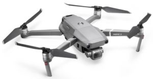 The Mavic 2 and older Mavic Pro is perfect for photogrammetry and lidar mapping applications. These quadcopters all use the latest IMU and flight control stabilization technology to fly super smoothly. They also have a 4k stabilized integrated gimbal and camera.
The DJI Mavic will create very accurate point clouds and perfect 3D maps stitched together. The Mavic are all compatible drones for use with the top 3D mapping software from companies such as DroneDeploy or Pix4D.
Waypoint navigation is very important for creating accurate 3D photogrammetry images. The Mavic drones uses the Waypoints for its autonomous programmed flight.
However, all the top photogrammetry software will include waypoint navigation.
With a transmission range of 4.3 miles (7 km) and a flight time up to 27 minutes, you can cover a lot of ground.
Note: You can read further this quadcopter in the DJI Mavic Pro highlights and FAQs article.
Drone Mapping With DJI Matrice 600
The Matrice 600 (M600) is DJI’s new flying multirotor platform designed for professional aerial photography and industrial applications. It is built to closely integrate with a host of powerful DJI technologies, including the A3 flight controller, Lightbridge 2 transmission system, Intelligent Batteries and Battery Management system, for maximum performance and quick setup.
The modular design of the M600 makes it quick and easy to set up. All Zenmuse cameras and gimbals are compatible with the Matrice 600, with a maximum payload of 6 kg allows it to fly the Ronin-MX gimbal and a range of cameras from Micro Four Thirds systems to the RED Epic. Top quality cameras along with an super stable multirotor will give you perfect 3D maps every time.
The M600 features an extended flight time and a 5 km long-range, ultra-low latency HD image transmission for accurate image composition and capture.
This multirotor uses 6 small DJI intelligent batteries with a customized battery management system and power distribution board allowing all six batteries to be turned on with one button press, and keeps the system in flight in the event of a failure of a single battery, and allows users to check the battery status in real-time during flight.
The Matrice 600 has enhanced GPS with allows for highly accurate photogrammetry. The enhanced GPS also allows you to track the Matrice 100’s position in real time, while enabling faster satellite acquisition, more accurate position holding and flight planning.
You can read further on the DJI Matrice here.
DJI Phantom 4 Pro For Photogrammetry
The DJI Phantom 4 Pro released in can use the Pix4Dmapper Mesh DJI edition. The Phantom 4 also works with Drone Deploy and Site Scan software mentioned further down this post. The Phantom 4 flies perfectly smooth, uses dual navigation systems, uses obstacle detection and collision avoidance sensors. It has a 4k camera. Very importantly it also uses waypoint navigation.
It the one of the most popular quadcopters to be used for 3D imaging. You can read further on the Phantom 4 Pro below.
Top Phantom 4 Pro Intelligent Flight Modes.
Full Phantom 4 Review with videos.
This first videos shows you how to create 3D Model using the DJI Phantom 4 and the Photogrammetry mapping Agisoft PhotoScan software.
DJI Phantom 3 And Inspire 1 Photogrammetry
In September 2015, a firmware and software update gave the DJI Inspire 1 and Phantom 3 models waypoint navigation and can now be used for photogrammetry. This next video gives a demonstration of using the Drone Deploy Mapping software to create 3D maps with a DJI Inspire 1, Phantom 3 and Phantom 4 drone.
The best software to use with DJI drones is perhaps DroneDeploy and the Pix4DModel and Pix4DMapper solutions. Also the Altizure app is pretty good for photogrammetry. More information on the Pix4DMapper and Altizure for 3D mapping and modelling below.
DJI Ground Station With Photogrammetry
On December 2015, Google stopped supporting Google Earth and DJI’s PC Ground Station software which was based on the Google Earth API. This means that DJI have discontinued support for their own PC Ground Station. However, there are a range of 3rd party software ground stations solutions including some which are built into the actual 3D mapping software.
Other UAVS For Photogrammetry
SenseFly eBee X Mapping UAV
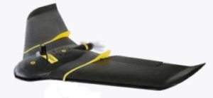 The Sensefly eBee X is the fixed-wing drone designed specifically for all your mapping needs. It was designed to boost the quality, efficiency and safety of your data collection.
It has a camera to suit every job with exceptional accuracy and coverage to meet every project’s requirements, and can work with practically every type of site.
The eBee X has a maximum flight time of 90 min and has a vast coverage of up to 500 hectares (1,235 acres) at 400 feet, while its high precision on helps you to achieve absolute accuracy of down to 3 cm (1.2 in), without GCPs (Ground Control Points).
The eBee X suits every job thanks to its range of groundbreaking cameras. These include the following;
- SenseFly S.O.D.A. 3D, for stunning 3D reconstructions of vertical environments
- SenseFly Aerial X RGB photogrammetry camera
- SenseFly Duet T for creating geo-accurate thermal maps
- Parrot Sequoia+ to captures images across 4 defined, visible and non-visible spectral bands, plus RGB imagery
- SenseFly Corridor simplifies the drone mapping of linear infrastructure and sites
SenseFly eMotion Ground Station Software
A drone’s flight management (or ground station) software is advanced, scalable and very easy which anyone can use.
eMotion helps you get your drone in the air quickly, while including all the functionality you need to collect and manage exactly the geospatial data you require. It supports both fixed wing and multirotor drones.
The output compatibility includes;
- Orthomosaic raster
- Index map
- 3D point cloud
- Digital surface models (DSM)
- 3D mesh with texture
- Contour lines
- Google Maps / Mapbox tiles
- Undistorted images
The compatible output can be pulled into the top software products such as ESRI ArcGIS, GlobalMapper, Autodesk, Google Earth, DraftSight, QGIS, GeoMedia, AgPixel, SMS Ag, Trimble RealWorks, Bentley MicroStation, 3DReshaper and many more.
WingtraOne 3D Mapping Drone
The WingtraOne is a VTOL (vertical take off and landing drone) designed specifically for surveying and 3D map building.
The vertical take off and landing capability allows the WingtraOne to ascend and move like a helicopter. For a mapping mission, it takes off directly in the air and then transitions into forward cruise flight and matches the endurance and speed of fixed wing airplanes. In order to land, the WingtraOne switches back to hover flight and descends vertically.
Wingtra One Camera For Photogrammetry
The WingtraOne increases precision and survey mission success by carrying a 42 megapixel photogrammetric grade camera and an ultra low distortion lens.
The WingtraOne covers 100 hectares at 0.7 cm per pixel resolution in a single flight or 400 hectares at 3 cm per pixel resolution. This makes WingtraOne missions exceptional in comparison to other surveying and mapping drones. The WingtraOne is;
- 2 times more precise as flights with a 20 MP camera.
- Cover 10 times more area than multicopters.
- 5 times faster than terrestrial measurements.
Wingtra Pilot Software
WingtraPilot is the intuitive user interface to manage WingtraOne’s data acquisition process. It includes ways to plan missions, monitor and revise the mission during flight and inspect the data output in the field.
All aerial images and geo-location information is stored on a single SD card and can be inspected in the field on the WingtraPilot tablet for early quality checks. WingtraPilot offers the ability to geo-reference images of multiple flights at the end of the day to minimize idle time on site.
WingtraOne Compatible Photogrammetry Software
The results are compatible with all major stitching and analysis tools such as Pix4D (recommended), DroneDeploy, PhotoScan and Precision Mapper.
This next video introduces you to the WingtraOne VTOL mapping drone. It is an absolutely superb drone with state of the art mapping technology.
Here is nice look at the WingtraOne mapping and photogrammetry drone.
Aeryon Scout Map Edition Quadcopter
The Aeryon sUAS is designed for any application which requires survey-grade accuracy orthomosaics, DSMs and point clouds from aerial or oblique imagery – and seamless integration with GIS, CAD, and traditional photogrammetry software.
The Aeryon Map Edition includes the Aeryon SkyRanger sUAS, the integrated imaging payload for image capture and Pix4Dmapper software to enable field and office image processing, including integrated tools for 3D output visualization and editing.
Drone Mapping And Modelling Photogrammetry Software
Below, we have highlighted just a few of the photogrammetry software packages on the market. We have published another article, which covers the best photogrammetry software for creating 3D maps on the market.
Pix4Dmodel Software
The Pix4Dmodel mesh software makes the creation of 3D models from images automatically and very easily. All you need is a camera and the Pix4Dmodel software. This Pix4Dmodel Mesh works with any drones. Below are just some of the most popular drones on the market which you could us the Pix4Dmodel software with.
- DJI Mavic 2
- DJI Phantom 4 (All models)
- DJI Mavic Air
- DJI Phantom 3 Advanced and Professional
- DJI Mavic Pro
- DJI Inspire 1 (X3, X5 cameras)
- DJI Inspire 2
- Parrot Bebop 2
Pix4DMapper Photogrammetry Software
Pix4Dmapper photogrammetry software allow you to generate professional 3D models and maps from images. This Pix4Dmapper software turns your images into highly precise, geo-referenced 2D maps and 3D models. The 3D maps are customizable and complement a wide range of applications and software.
Pix4DMapper Key Outputs And Features
Here is just a few features from the Pix4D photogrammetry mapping software;
- Densified 3D Point Cloud – This is a set of 3D points that reconstruct the model. The X,Y,Z position and the color information is stored for each point of the Densified Point Cloud.
- Digital Surface And Terrain Model – Get the elevation value of each pixel, with or without above-ground objects, ready for your preferred GIS workflow.
- Orthomosaic – A geolocated high-resolution map with each pixel of the original images projected onto the digital surface mode.
- Volume Calculation – Accurate volume calculations on a perfect representation of your stockpiles, with fully-adjustable base height.
- Contour Lines – A simplified representation of the topography with closed contours displaying the elevation.
- 3D Textured Model – Triangular mesh with photo realistic texture.
- Reflectance Maps – Assess reflectance based on the pixel value in multispectral or thermal imagery.
- Index Maps (NDVI, NDRE) – Work with well-known indices such as NDVI and NDRE used by agriculture drones or create custom indices.
- Application Maps – Aggregate and visualize the values derived from your index maps.
- Thermography – A radiometrically-accurate map with a temperature value of each pixel.
Trimble Inpho UASMaster
The Trimble Inpho UASMaster is a complete photogrammetric workstation for UAS and terrestrial close range imagery. Trimble has over 30 years of experience in digital aerial photogrammetry.
Its new UASMaster combines modern computer vision algorithms, with proven state of the art photogrammetric techniques, to produce accurate results automatically, with minimal manual interaction.
Some of the Trimble Inpho UASMaster highlights are as follows;
- Open for any fixed wing, multirotor or handheld frame camera.
- Special support for high quality GNSS / IMU data for stable processing in challenging conditions or to eliminate need for ground control.
- Streamlined workflow to automatic feature extraction with eCognition and perfect integration into Trimble Business Center for classic survey application.
- Intuitive guided workflow concept for the photogrammetric beginner.
- Fully compatible with Inpho photogrammetry modules from Trimble.
Altizure Free Photogrammetry Software
The Altizure app allows for fully automated 3D mapping of an area. You outline an area on the map and the app will calculate the best route to take images of the area.
These images can then be uploaded to Altizure website, where it is analyzed by its software to create a 3D render of your location (you can also animate your creation).
The compatible drones are the DJI Mavic, Phantom 3, 4, Inspire 1 and Inspire 2. Altizure have a free version and also a paid for service.
Here is a sample of the quality output using a drone and the Altizure app.
Drone Deploy App
The DroneDeploy software app automates drone flight and makes it so very easy to capture aerial images. The DroneDeploy platform processes your UAV images using computer vision turning them into 2D, 3D maps and models.
All you need is a drone and a mobile device with the DroneDeploy mobile app installed.
The images captured by the drone are geotagged, which assist in creating the maps. As the drone is flying, a 2D map will appear in your DroneDeploy app. When finished you then upload the photos to the DroneDeploy website. After a few hours the photos are meshed into a 3D map or model.
Drone Deploy mobile app features;
- Easily make flight plans on any device
- Automate takeoff, flight, image capture and landing
- Live stream First Person View (FPV)
- Disable auto-flight and resume control with a single tap
- Easily continue non-interrupted flights to map large areas
- Explore Orthomosaic, NDVI, Digital Elevation interactive maps and 3D models
- Measure area and volume instantly
- Collaborate with a team through shared maps and comments
- Get help when you need it with in app support
Precision Mapper & Viewer Photogrammetry Software
PrecisionMapper works online to automatically processes aerial data into 2D or 3D products. It features a continuously expanding library of on demand analysis tools, and makes sharing or collaborating very easy.
Here is how this PrecisionMapper photogrammetry software works;
- Collect aerial data with your drone
- Upload data to your account and process 2D or 3D products
- Manage, collaborate, and share data with anyone
- Analyze data with a library of on-demand analysis tools
Precision Mapper Key Outputs
- Orthomosaics
- 3D models
- Crop health analysis tools
- Volume measurement
Precision Viewer
PrecisionViewer is a desktop software which allows users to easily view flight path coverage, add ground control points, and attach flight logs and flight bounds to surveys.
UAVs Photogrammetry And LiDar Mapping Videos
This videos shows the monumental task of creating the 3D Model of the Christ the Redeemer Statue in Rio de Janeiro.
This next video comes from Tim Lucas which demonstrates how UAV’s carrying photogrammetry payloads are being used.
Below is a nice tutorial video on LiDar technology. This video shows traditional aircraft being used for LiDar mapping. However, we are already seeing that UAVs are more practical and cost effective for LiDar mapping.
This final video shows you the SiteScan software working with the 3DR Solo drone and how easy it is to create a 3D photogrammetry map. The 3DR SiteScan software now works with the DJI Mavic and Phantom drones. With a doubt, creating aerial 3D photogrammetry images has never been easier.