This DroneDeploy review takes a look at the app and platform features, including pricing of their excellent solutions used to create meaningful aerial data in the cloud.
Below, you will also excellent DroneDeploy tutorials and closer to the bottom, we have links to manuals, the DroneDeploy forum and contact details including phone number.
Sprinkled throughout, you will find some excellent DroneDeploy tutorials.
Now, DroneDeploy are one of many companies in the aerial mapping software solutions sector. There are many DroneDeploy alternative software solutions out there and we will list and give links to these.
Okay, let’s start with a look of the DroneDeploy apps and platform.
DroneDeploy Review – App And Platform
The DroneDeploy software app automates drone flight and also makes it very easy to capture aerial images. The DroneDeploy software platform processes the UAV images using computer vision turning them into 2D, 3D maps, models and more.
Since 2013, the DroneDeploy software platform have processed millions of images and created thousands of maps. It is regarded as the leading drone mapping app and platform available.
DroneDeploy Mobile App – So Easy To Use
All you need is a drone and a mobile device with the DroneDeploy mobile app installed. With your drone switched on, then open up your DroneDeploy mobile app. Next, select the ground area you would like to create the map off.
Then, with just one more tap in the DroneDeploy software, the drone will take off and fly 100% autonomously over the target area taking high resolution photos at regular programmed intervals.
The images captured by the drone are geotagged, which assist in creating the maps. As the drone is flying, a 2D map will appear in your DroneDeploy app. When finished you upload your photos to the DroneDeploy website. Wait a couple of hours and your photos are meshed into your 3D maps or model.
Drone Deploy mobile app features;
- Easily make flight plans on any device
- Automate takeoff, flight, image capture and landing
- Live stream First Person View (FPV)
- Disable auto-flight and resume control with a single tap
- Easily continue non-interrupted flights to map large areas
- Explore Orthomosaic, NDVI, Digital Elevation interactive maps and 3D models
- Measure area and volume instantly
- Collaborate with a team through shared maps and comments
- Get help when you need it with in app support
Drone Deploy Mobile App Download
The DroneDeploy download can be found on the below links;
Here is a nice introduction to the DroneDeploy mobile app.
DroneDeploy Live Map – Realtime Mapping
The DroneDeploy Live map only recently developed is available for iOS devices and is even better than the mobile app. The Live map will create 3D maps while it is flying the target area.
In other words, drone maps created in realtime on your mobile device. This allows you to view data which you can act on straight away. There is no need to wait for the data to be uploaded and then processed. It is creating the maps and model and the drone flies.
Here is a few of the major benefits of the DroneDeploy Live Map.
- Instant Results – Generate aerial insights in seconds and sync your data to the cloud
- Onsite Insights – Visualize and take immediate action with RGB and thermal imagery
- Mobile Maps – Plan a flight, take off and see maps render onscreen during flight
- Fast – Get an aerial view of your job site, field, or project faster than ever before
- Realtime – Turn hundreds of acres into consumable maps without going back to the office
- Collaborate – Share maps with clients, collaborators, and analysts in minutes as no uploads necessary
- High Resolution Data – Create high-resolution maps for further analysis on any device from the same flight
Now, with live map, you can still upload your images for further processing into full 3D models.
Thermal Live Map Solution
With Thermal Live map, you can easily identify areas of interest as your drone flies. The Thermal Live map visualizes temperature range variability on your mobile device in realtime. You can then share the thermal map with your team immediately.
Having thermal imagery allows for surveying of of power lines, buildings, solar panels, pipelines, detect irrigation problems in agriculture land and are of tremendous use to fire departments and rescue services at night time.
Below is an introduction video to the DroneDeploy Live Map for iOS devices.
DroneDeploy Compatible Drones
In reality, you can use any drone to capture images. Then upload them to DroneDeploy and they will create the maps and models for you. However, DroneDeploy recommend the following DJI drones for use with their Mobile and Live Map applications.
- Skydio 2 (New)
- Mavic Pro
- Mavic 2 Pro
- Phantom 4 Advanced
- Phantom 4 Pro V2
- Inspire 1
- Inspire 2
- Matrice 100, 200 & 600
If you are new to photogrammetry and want to start working with 3D maps and models, then the above Mavic Pro and Phantom 4 drones are terrific.
You can also learn more on how 3D maps and models are created in this article entitled “UAV Photogrammetry and Lidar Mapping Basics“.
This DroneDeploy tutorial shows you just how easy it is to use the DroneDeploy mobile app and create a 3D map. You can see how the DroneDeploy app is terrific for both beginners and experts.
DroneDeploy App Outputs
To create a high resolution 3D map or model, upload your images to Drone Deploy cloud platform. Their software uses computer vision and algorithms to mesh the photos together to generate the 3D maps.
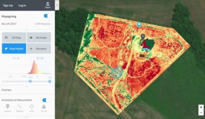
Other data output include volume measurements and Normalized Difference Vegetation Index (NDVI), used by multispectral farming drones.
The DroneDeploy app on its own allow you to do the following;
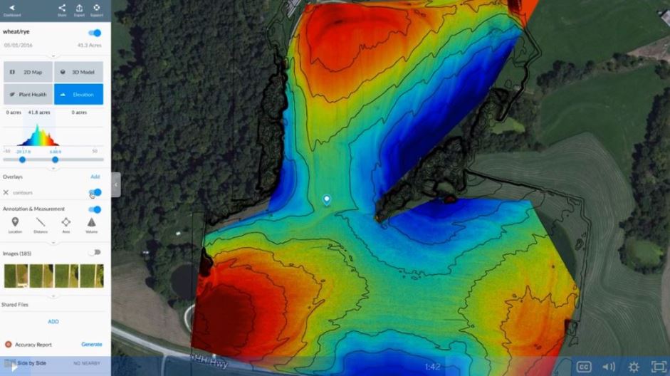
- Measure volume
- View elevation data
- Monitor plant heath
- Generate contour lines
- Track changes of an area or project over time
- Create and view 2D and 3D orthomosaic maps
- Output in many formats (JPG, TIFF, OBJ, LAS, SHP, DXF)
Key Sectors Using DroneDeploy Solutions
Visit the below links to see how the DroneDeploy app and platform and benefiting each of these sectors;
DroneDeploy Case Studies & Blog
The DroneDeploy blog contains information including real life examples and stories to give you a feel how you can use their apps and platform in your sector. Here are some of the success stories being created by the DroneDeploy software.
Drone-based Volume Measurement Brings Savings to Mining
Winning a Mining Client with an Accurate Contour Map
Mapping 1,000 Kilometers of Highway in Mexico
Drone Map Saves Insurance Company €99,985,000
Drone Helps Verify Earthwork at Hospital Construction Site
DroneDeploy App Marketplace – Integrate With 3rd Party Solutions
There are over 80 apps, which integrate with the DroneDeploy app and platform.
The DroneDeploy app marketplace allows for even better outputs and meaningful data for surveying, volumetric measurements, monitoring crop health, build maps and models.
Example of the apps which integrate with DroneDeploy are AutoDesk, ArcGis, John Deere, Agremo, Skymatics, EZroof and many more.
You can view the full DroneDeploy app marketplace here. The app marketplace puts DroneDeploy ahead of many of its competitors.
DroneDeploy Developer Platform
You can create and streamline your workflow by integrating drone data directly into existing software or build you own custom applications from within the DroneDeploy interface. The DroneDeploy developer platform allows you to build your own custom applications to suit your needs.
Drone Deploy Enterprise Platform – Collaborate And Share
The DroneDeploy software platform creates the 3D maps from the images stored on their servers in the cloud. DroneDeploy take care of your data making sure it is always available and backed up.
3D maps can be massive in size and require a lot of power to process the images into maps and models, which can produce meaningful data.
Generally, your standard computer or laptop wouldn’t have the processing power to create these high resolution maps quickly. DroneDeploy has the server power and bandwidth to process the images into high resolution maps and models.
Their online solution means you can view and analyse you data on any internet connected smartphone or computer.
The DroneDeploy platform is flexible and you can add users to share your models with. This allows for collaborating and inputs from many parties if needed.
Drone Deploy Pricing Costs
Let’s take a look at the various DroneDeploy pricing and costs starting with the free trial.
DroneDeploy Free Trial – Explorer Plan
The DroneDeploy mobile app is free to use and all new users have a 14 day trial. The free trial DroneDeploy Explorer plan enables you to create 2D maps and 3D models without charge.
You get some of the great functionality offered by the platform, such as automated flying, image processing and sharing including annotating your maps. However, you are limited in terms of the number of maps you can process and other advanced capabilities (volumetric calculations, data exports, etc).
DroneDeploy Pro Pricing Plan
This is ideal for an individual launching a drone small program. It costs $996 annually. If you pay month by month, then the cost is $129 per month, which would bring the DroneDeploy cost to $1,548 for the year.
The DroneDeploy Pro Plan has the following features;
- Live Map: Realtime mapping
- Up to 1,000 images/map
- Email & chat support
- Individual user
- JPG, Geotiff, OBJ
- Volume Measurement
- 70+ Apps in the app marketplace
DroneDeploy Business Pricing Plan
The DroneDeploy Business pricing plan is ideal for teams, which require larger maps, more data, and more export types. It costs $2,988 annually. If you pay month by month, then the DroneDeploy cost is $399 per month, which would bring the cost to $4,788 for the year.
The DroneDeploy Business Plan has the following features;
- All Pro features plus
- 3,000 images/map
- Email & chat support
- Add 2 users at $999 per user/year
- Point Clouds
- LAS, XYZ, Shapefiles, DXF, Contours
- Local projection systems
- Multi-user management
- Co-Branded maps and reports
- GCPs – $49/map
DroneDeploy Enterprise Custom Plan
The DroneDeploy Enterprise plan is for large teams which require advanced security and need a customized solution. The DroneDeploy team with work with you on the solution and the pricing model will reflect the solution.
The DroneDeploy Enterprise Plan has the following features;
- All Business features plus
- 5,000 images/map
- Dedicated success manager
- Custom number of users
- API access
- Single sign in
- Roles & permissions
- Activity audit view
- Data viewer
- Unlimited GCP maps
- Unlimited DTMs
- Roof reports
DroneDeploy Manuals and Documents
You will find a huge amount of invaluable DroneDeploy documentation and manuals here. This includes subject heading with plenty of information under each heading.
- Frequently asked questions
- Account management
- Capturing data
- Processing data
- Analyzing data
- Sharing data
- Security
- Exporting data
- Troubleshooting
- DroneDeploy enterprise
- DroneDeploy app market
- Application development using API
DroneDeploy Webinars
Here is a link to all the DroneDeploy webinars which have taken place in the past. These DroneDeploy webinars include;
- Beginner drone clinic
- Intermediate drone clinics
- Advanced drone clinics
- Drones in agriculture
- Drones in construction
- Getting started with drones in construction – Part 1
- Getting started with drones in construction – Part 2
DroneDeploy Alternatives
 DroneDeploy can cover almost all sectors for drone based mapping. All their solutions are is easy to use.
Their mobile app, live app and enterprise platforms are top technology and DroneDeploy put huge efforts into continuous improvements. The DroneDeploy support is also being exceptional.
Their are many DroneDeploy alternatives on the market. If you are new to mapping and modelling, it is essential to trial the many photogrammetry mapping software solutions on the market.
Some of these photogrammetry alternatives are very specific to building, agriculture on creating models of buildings.
Many are excellent at what they do and their costs vary with a number of free photogrammetry packages available in the below list. For example “Open Drone Map” is totally free but you need some technical knowledge to get it up and running.
There are all similar and yet have enough differences at the same time. All of the below software have free trials and you will find many YouTube photogrammetry tutorials and reviews of these DroneDeploy alternatives.
Here are a few DroneDeploy alternatives;
- Pix4D Mapper photogrammetry software
- AutoDesk ReCap photogrammetry Software
- Maps Made Easy orthophoto and 3D models software
- 3DF Zephyr photogrammetry software
- Agisoft PhotoScan photogrammetry software
- PrecisionHawk 3D map software
- Open Drone Map photogrammetry software
- ESRI Drone2Map for ArcGIS
- 3DR Site Scan
You can read further on these DroneDeploy alternatives in this article entitled “Best Photogrammetry Software For Mapping And Modelling“.
About DroneDeploy Company
DroneDeploy is a private company and was founded in 2013 by Mike Winn (CEO), Jono Millin and Nicholas Pilkington (CTO). The DroneDeploy office is in San Francisco, California and they have over 100 employees.
The idea for DroneDeploy came about through efforts to assist park rangers in Kruger National Park in South Africa. The 3 friends wanted to leverage drones to help catch poachers, which were illegally hunting rhinos in the park. With only 650 rangers to protect the 7,523 square mile park, it was impossible to patrol the entire area.
There wasn’t any real drone mapping software in 2012. At that time, there were only large ground stations and Windows based PCs, which required a big investment and plenty of training. There was no easy and intuitive software solution to fly drones autonomously.
From there, DroneDeploy was born. Mike, Nick and Jono set out to create a drone software platform, which anybody can use to create and share high resolution maps with imagery to support every commercial use.
DroneDeploy Contact Details
DroneDeploy Phone Number: +1 507-593-7663
Location Address:
DroneDeploy Tutorials
To finish, we have another couple of DroneDeploy tutorials showing you how their software works in various sectors.
This next video show you how to use DroneDeploy to create a 3D model.
How to easily create a new flight plan is covered in this next video. The DroneDeploy video is using a DJI Mavic Pro.
This last Drone Deploy Mapping is a demo tutorial for 3D mapping with the DJI Mavic Pro drone, which includes plant health NVDI Mapping & 2D mapping.