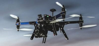
The 3DR X8 quadcopter range is without doubt top notch. In this X8 quadcopter review, we look at this powerful, reliable and easy to fly drone along with its options and uses. We review both the X8+ for aerial photography, the X8-M for mapping and the Mission Planner software.
What the X8 quadcopter gives you in abundance, is options in its use. It is an autonomous drone which can take off, fly the path you have programmed in and land again. 3DR who are at the forefront in drone innovation have created a very robust platform for both aerial filming with the X8+ or creating sophisticated 3D maps and models with the X8-M quadcopter.
The opportunities which exist today in both aerial filming and 3D mapping are endless. New innovative uses for drones in sectors such as Mining, Construction, Oil & Gas, Real Estate, Film Studios, Universities, Agriculture, Fire Departments, Security, Environmental Works and Conservation.
NOTE: This article is a few years old now and the technology is out of date. We have a new article, which covers the latest Photogrammetry software and drones for generating 3D maps.
3DR X8-M Quadcopter Review For Mapping
The X8-M quadcopter is a platform for all types of aerial mapping. It comes with the Pix4Dmapper LT 3DR Edition software along with the Canon SX260 high resolution 12 MP camera. With this high quality camera you can also use the X8-M quadcopter for straight forward aerial filming. The X8-M quadcopter really is a multipurpose package.
The X8-M quadcopter can generate highly accurate photogrammetry maps, 3D models, collect aerial data using automated flight, use repeatable flight paths, gather data beyond the visible eye, generate point clouds for precision survey and can even be fitted with magnets for deliveries. The X8-M has plenty of options for fitting many different gimbals and cameras including infrared.
Canon SX260 Camera Features (X8-M Quadcopter)
- GPS Enabled
- 12 Megapixels
- 20 x Optical Super zoom
- 7-mode image stabilization system
- Max Resolution – 4000 x 3000
- 1080p -24 FPS HD video
 With aerial mapping and using the Pix4D software, you can use the GPS co-ordinates from the Canon SX260 camera or from the X8-8M quadcopter. Both the camera and the quadcopter have memory card slots. The GPS co-ordinates from the X8-M will be slightly more accurate than the camera. The level of detail and accuracy of the X8-M is pretty outstanding;
- Ground sampling distance and resolution: 0.7 inches per pixel (2 cm per pixel).
- Orthomosaic accuracy: 3 – 16 ft (1 – 5 m).
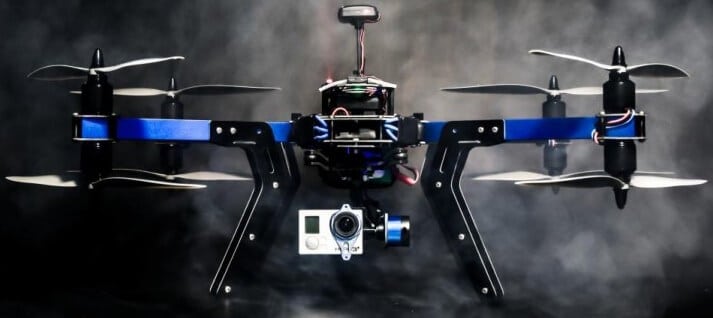
With the X8-M, the camera is mounted to the underside of the quadcopter. The X8+ for aerial filming comes with the Tarot 2 Axis brushless gimbal.
Pix4Dmapper LT 3DR Edition Software (X8-M Quadcopter)
The Pix4Dmapper software processes aerial images based purely on the image content. The software converts images for a wide range of GIS and CAD applications. The software has many processing options. You can view the quality of the images while the X8-M quadcopter is flying and make changes if required.
Learning Pix4D Software
If you are new to the world of mapping, 3D modelling and precision surveying, there is plenty of help and resources. It is software which anyone can learn. One of the best resources is the Pix4D YouTube channel. The software comes with plenty of tutorials and links to their online support and knowledge base.
The best way to learn mapping and 3D modelling is to create autonomous missions with your X8-M quadcopter. Take photos of an area and use the software to stitch together the images into maps and 3D models. Choose different options, try out the different configurations and you will learn pretty quickly while having fun at the same time.
3DR X8+ Review For Aerial Filming
The X8+ quadcopter is geared towards straight forward aerial photo and filming. It comes with the GoPro Hero4 camera. However, you could use the X8+ quadcopter for aerial mapping. You can buy the Pix4Dmapper LT 3DR Edition software separately directly from Pix4D.
 GoPro Hero4 Camera (X8+ Quadcopter)
The GoPro Hero4 camera is quite similar and in many ways it is a better camera than the Canon SX260 which comes with the X8-M.
However, the Canon SX260 has GPS and a 7 mode image stabilization system which gives it an advantage for 3D mapping and precision surveying.
For aerial filming, the GoPro Hero4 is by far the most widely used camera by drone flyers whether as a hobby or for commercial use. Perhaps 80% of the drones videos on YouTube are captured using the GoPro Hero3 and Hero4 models.
You can see some great scenery and aerial filming using the GoPro camera in our best drone videos category of articles on this website.
Video: The below video shows you the X8+ quadcopter filming in some magnificent countryside. The pilot sure is an expert, flying low and fast, then sweeping up over a fine house while capturing terrific aerial video.
X8 Quadcopter Features
Both the X8+ and X8-M quadcopters have these same features:
- Easy to assemble when first purchased. From then on, you have a ready to fly heavy duty quadcopter.
- Flight time: Average of 14 min which has an area coverage of 25 acres for mapping.
- Can fly at very low altitudes and at slow speeds, which means the aerial images have a high level of detail and precision.
- Maximum operational wind speed of 25 mph (11 meters per second).
- 3PV™ Follow Me Technology. Program the X8-M quadcopter and it will follow you around. Great for sports and travel filming.
- Compatible with the 3DR LiveView monitor.
- Telemetry radio: 3DR Radio V2 – 915 mHz (US & Canada) and 433 mHz (all other countries).
- Radio range: 0.6 miles (1 km).
- Landing accuracy: 8.2 ft (2.5 m).
- Recommended payload 800 grams but can carry over 1 kg with flight time reduction.
- Mix and match different gimbals and cameras giving you plenty of freedom to decide how you want to use the X8.
- Suitable for different types of sensors and can even automate the delivery of small goods.
- Strong aluminum frame and well able to take the elements. At the same time it is light enough to maximize aerial mobility.
- The frame folds making it perfect for onsite use in areas like mining, construction, search and rescue, agriculture and professional cinematography.
- An innovative motor system for reliability.
- 3DR fully automated flight control for ease of use and flight protection.
3DR With FAA Exemptions
Here is some great news for 3DR or anyone looking to enter the commercial drone industry to take on clients for aerial mapping or cinematography.
On Friday 13th 2015, the FAA granted under Section 333 authorization for commercial use of 3DR drones to two companies, BNSF Railway and Build Imagery. The exemptions will not only allow these companies to use 3DR drones for business purposes, but will also enable all parties involved to continue to test and refine 3DR drone technology for industrial applications.
X8+ Quadcopter Brushless Gimbal
The X8 quadcopter comes with the 2 axis Tarot Brushless Gimbal. This gimbal has real quality using gyroscope technology to ensure you receive really crisp, stable images from your X8. The Tarot-2D automatically compensates for the smallest of movements, enabling you to capture very steady video even in windy conditions.
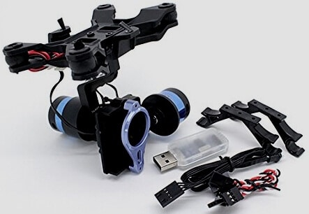 It is designed to hold the GoPro HERO 3 and 4 cameras. The Tarot 2D Brushless Gimbal from 3D Robotics is pre-wired, calibrated and configured to work with your X8+ quadcopter.
This gimbal has the manual camera control from your controller’s tilt knob.
However, the model you receive from 3D Robotics is configured to allow the autopilot to control the camera automatically.
This gimbal leaves the factory assembled by 3DR and includes the mounting plate and hardware for the X8+.
3D Robotics X8 Warranty And Returns
All 3D Robotics products have a 90 day warranty.
About 3D Robotics – A Great American Story
Founded in 2009 by Chris Anderson, former editor in chief of Wired Magazine and Jordi Muñoz, a model plane enthusiast and computer programmer from Ensenada, Mexico.
Jordi was unemployed when he first came to the US. But he used his skills and knowledge to build his first quadcopters. He met Chris Andersons through the DIY drones website and it took off from there. It’s a terrific success story on how an Mexican immigrant set up a global drone firm.
3DR is a VC backed startup with over 200 employees in North America. It’s headquarters are in Berkeley, California. 3DR also have an engineering premises in San Diego, marketing in Austin, Texas and manufacturing in Tijuana, Mexico.
Worldwide Customers
This year 3DR are expecting to enjoy sales of USD 50 million. 3DR have more than 30,000 customers worldwide.
I hope this article assists you in choosing the correct X8 quadcopter for your requirements whether as a hobby or as a commercial business. Enjoy flying, aerial filming and creating maps and models.