Introduction To UAV Photogrammetry And Lidar Mapping Basics

Using UAVs for photogrammetry and aerial LiDar mapping

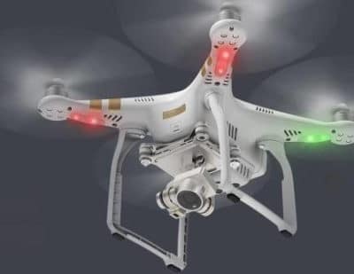
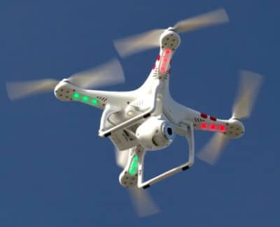
UAV lidar and photogrammetry imaging applications are increasing rapidly. This is not surprising as using GPS enabled UAVs for aerial surveying is very cost effective in comparison to hiring an aircraft with photogrammetry equipment.  

Because UAVs are relatively inexpensive, organisations will have their own UAV fleet, allowing for rapid surveys over large land areas and infrastructure projects where required. 

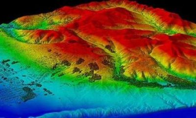
With GPS equipped drones, digital cameras and powerful computers, surveys have an accuracy right down to 1 centimeter.

This post takes an overall look at this drone mapping technology. We also take a quick view at the sectors benefiting from using UAVs for photogrammetry and lidar mapping.  We also look at some of the best mapping drones on the market along with the compatible software.

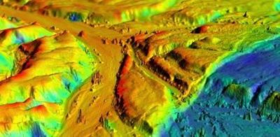
Another closely related sector is using LiDAR sensors mounted onto drones.  It’s another growing sector and you can read further regarding drone LiDAR use here. 

Read more

DJI Phantom 3 Drone Reviewed And Very Low Prices

DJI Phantom 3 Review of both the Professional And Advanced Model

In this Phantom 3 review we look at its innovative technology and features which make this drone the most popular on the market. In the past couple of weeks the DJI Phantom 3 has become even better value with lower prices.  Further down this post, I have links to where you can get the best prices for the Phantom 3 Professional, Advanced and Standard models.

Even though, there are newer drones from DJI on the market, the  Phantom 3 nevertheless has everything you would want in a drone.  Many of the top aerial landscape filming on YouTube have been filmed with the Phantom 3.

The Phantom 3 is very powerful, highly responsive and will fly precisely to your commands.  The integrated gimbal and camera greatly assist you to take professional aerial photos and film. Without doubt, the Phantom 3 is very impressive to fly and film with.

This Phantom 3 review with videos takes a close look at the flying and filming capabilities along with its features and improvements.  The Phantom 3 flies longer; has a 4k UHD camera; a new Vision Positioning system; stronger GPS signalling and reliability; a totally revamped remote controller; massive improvement in precision flying with much improved responsiveness and performance from both the quadcopter and camera.

Latest Drones

This post is quite old and while you can still find some Phantom 3 quadcopters available, the latest drones at low prices are pretty outstanding in comparison to the technology in the Phantom 3. You can also visit the DJI home page for their latest DJI consumer drones.

Read more

UAVs In The Lidar Applications Sector Increases Substantially

Lidar Applications And Systems Using UAVs

The market for lidar UAVs and their applications is growing fast and and will continue to increase over the next decade.  In 2015, the figure spent on drones using Lidar was around the USD 300 million.

However the lidar market is expected to rise to more than $1 billion by 2020. This is an increase of 20% year on year to 2020.

Many still view airborne lidar applications through the use of fixed wing pilot aircraft.  The high cost or renting lidar equipped aircraft, pilots, lidar trained engineers has kept the use of this extremely useful technology pretty much to the minimum.  Only big money and big budgets could afford to use airborne lidar systems regularly.

Read more

Top DJI Matrice 100 Review For Creating New Solutions

Top DJI Matrice 100 Review

The Matrice 100  drone can be programmed using the DJI Special Development and Guidance Visual Sensing System. This Matrice 100 review looks at the technology, specifications and features of this modular and adaptable programmable sensor drone.

This Matrice drone is designed with the developer in mind. It will  allow developers from all sectors to use the Matrice 100 as a platform to create new hardware and software applications and solve real life problems.

The Matrice 100 is a dual system.  You have the quadcopter and also the guidance visual sensing system as an add on.  It’s ready to fly straight out of the box.  The real benefit is in using the interface between the Matrice 100 and the DJI SDK to create new aerial solutions.

This quadcopter has sensors, a collision avoidance system and has tremendous options to customize. Because the Matrice 100 is highly advanced  and very customizable, it gives developers and engineers flexibility to be creative.   You customize and create solutions using the Matrice 100, the Guidance Vision Sensing System and the DJI Special Development Kit.

Read more

Walkera Technology Top Racing Drones And Aerial Filming UAVs

Walkera produce top aerial and racing drones

Walkera Technology is one of the top companies for professional aerial and racing drones not just in China, but globally.  Walkera have been very successful in the rc model toys since 1994 with over 50 helicopters and airplanes in their product range.

They have successfully transitioned to become a world class manufacturer of highly innovative and patented quadcopters and multirotors.

Walkera have 2 very strong competencies.  The 1st is their ability to design, engineer and develop new patented aircraft having a very wide range of drones and remote control toys.  Their 2nd strong ability is in the area of mold proficiency in which they use only the highest of precision equipment.

Read more

DJI Ground Station App And Setting Up Phantom 2 Waypoints

DJI Phanton 2 Ground Station App For Setting Up Waypoint Navigation

The Phantom 2 Ground Station app allows for the setting up of autonomous waypoints. What this means is that your Phantom 2 quadcopter  will fly autonomously from takeoff, then through its programmed points to its destination and also land safely.

It is exciting technology and shows us the potential of drones in everyday life.

The Ground Station app makes complex waypoint flying as simple as a few taps on a screen.  Before trying out waypoint navigation, watch the below DJI Ground Station tutorials a couple of times. Become familiar with the app and go through the below checks before flying using waypoints.

Read more

Prevent Phantom GPS Signal Loss And Failsafe Mode Tips

How to prevent GPS Signal loss on Phantom Quadcopters

When your Phantom loses GPS signal and enters failsafe mode, their are always some anxious moments as you are unsure whether your quadcopter will return to its home point.

If the Phantom is out of sight, the anxiety is even greater until you see your Phantom coming back to you.  It’s not a good feeling at all.

If your Phantom is losing the GPS signal regularly, you lose the enjoyment of flying and with each GPS signal loss, there is always a chance of your Phantom crashing.

This article with videos will give you some tips, checks and pointers to prevent GPS signal loss on your Phantom. A lot of the tips here are very practical and you can use this information to guide you in troubleshooting any drone not just a Phantom.

Read more

Improve Phantom 2 Vision+ GPS Signal With This Drone Tip

Drone DIY to improve the GPS Signal On The DJI Phantom 2 Vision+ drone

Problems with the GPS signal or loss of GPS on your Phantom 2 Vision is a worry and can lead to fly away issues or in the worse case, your drone crashing. This article and drone diy video below will show you how to improve the GPS signal on your Phantom 2 Vision+. You can look to use this solution on all Phantoms.

Loss of GPS signal appears to be a problem not just on Phantom drones but on all consumer drones. The problem can vary slightly and may not be entirely the manufacturers fault.

The Phantom really is a top quality quadcopter.  Some of the best videos of beautiful scenery and adventure on YouTube are filmed using the Phantom And GoPro combination. Being outdoors and flying your Phantom should be an enjoyable past time. If your Phantom is having GPS problems regularly, it takes the fun out of flying and limits you to flying your Phantom close to where you can keep your eyes on it.

I hope this Drone DIY procedure is easy enough for you to implement and fixes the GPS issues. Then you can fly your Phantom and enjoy the experience which is what it is all about.  Having fun flying your Phantom.

Read more

Top Business Drone Reviews For Aerial Filming And Mapping

Article reviewing the best drone for aerial view, UAV cinematography and photography

Drone use for aerial view, photography and cinematography is on a big upward trend.  More importantly there is a business opportunity for owners of the best quality drones and camera equipment to be hired for specialized work.  Using drones or renting drones along with professional pilots and photographers is a new sector with plenty of growth potential.

Read more

Drones, Quadcopters, Multi-rotors And UAVs Answered For Beginners

Article describes what exactly are drones, quadcopters and unmanned aircraft vehicles systems

For someone new and wants to learn about drone technology, it can get quite confusing. Today I’ll explain what are drones, quadcopters and UAVs as these names get thrown about quite a bit.

By reading and learning a bit about drones, purchasing and flying your first drone you will swiftly move away from a newbie to drones and start becoming an expert.

Read more