How Do Drones Work And What Is Drone Technology

Drone technology used in various popular Quadcopters

What is a drone and how do drones work is answered here in this easy to understand article. UAV drone technology is constantly evolving as new innovation and big investment are bringing more advanced drones to the market every few months.

Below, we discuss UAV technology on the most popular drones on the market, which have all the latest drone technology.  Most UAV drones will have very similar systems incorporated.

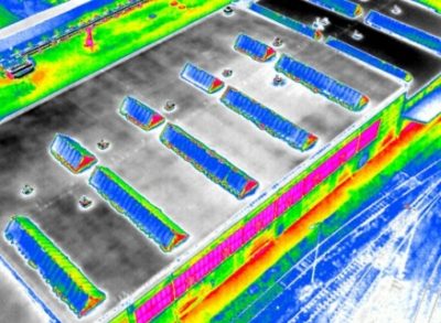
Also included is the latest list of top drones with cameras on the market right now.

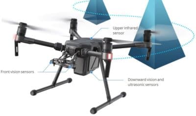
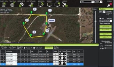
Unmanned aerial vehicle technology covers everything from the aerodynamics of the drone, materials in the manufacture of the physical UAV, to the circuit boards, chipset and software, which are the brains of the drone.

Read more

Top DJI Phantom 4 Pro Intelligent Flight Modes Reviewed

DJI Phantom 4 Intelligent Flight Modes

The Phantom 4 Pro intelligent flight modes make flying and producing meaningful aerial imagery so much easier.  Here, we review the Phantom 4 Pro including the new Phantom 4 Pro v2.0 intelligent flight modes, specifications and features.

The Phantom 4 Pro autonomous flight modes, along with new stabilization system and professional 4k camera make this drone an exceptional investment.

For aerial cinematography, the Phantom 4 flight modes allow you the capture film from various different flying angles.

The Phantom 4 Pro is an excellent quadcopter for professional site surveying, 3D imaging of terrain and photogrammetry of structures.

You can read further on these uses in this the article “Introduction To UAV Photogrammetry and Lidar Mapping“.

The Phantom 4 Pro also has many autonomous safety systems such as obstacle detection and smart return to home technology.

Read more

12 Top Lidar Sensors For UAVs, Best Lidar Drones And Great Uses

7 Top Lidar Sensors For Drones

Lidar sensors on UAVs capture imagery which only a few years ago needed an aircraft carrying large heavy lidar sensors and a crew to accomplish.

Here, we look at 12 of the best lidar sensors for drones along with the best lidar drones.

We feature lidar sensors from manufacturers such as Velodyne, Routescene, Leddartech, Riegl, YellowScan, Leica and Geodetics.

The lidar drones include quadcopters, fixed wing drones, UAV helicopters from manufacturers such as DJI, Harris, Velos, Vulcan, OnyxStar and many more.

A lidar sensor mounted on a UAV, along with the lidar software can process images very quickly in the cloud, allowing for effective decisions to be made by stakeholders and relevant parties.

The output from these lidar drones and sensors is outstanding.  The pace of development and improvement in the lidar sensors over the past few years has been tremendous and will continue with more entrants into this sector.

Over the coming years, we are going to see most of the lidar sensor work moving from aircraft to lidar drones.

In fact, all the manufacturers of the large lidar sensors for airplanes have developed smaller lidar sensors for drones.

We start off this post with the lidar drones being used for the various sensors, followed by how lidar sensor technology works. Then, we look at the best lidar sensors for drones.  Along the way, we have some terrific lidar drone sensor videos.

Read more

What Are Drones Used For From Business To Critical Missions

What are drones used for answered with full list

What are drones used for answered here covering every sector you can think of.  Drones are being used to save lives, environment works, archaeology, farming, property management, mining, construction and much more.

We start by looking at what drones are used for in specific sectors and include some terrific videos along the way.

The drone industry is growing fast and every week we see press releases and research papers on what new areas drones are being used for.

The usage of drones in some of these sectors was originally completed using helicopters and airplanes. However, these are expensive to hire and not always available when they were required.

Using helicopters and airplanes is also very time consuming as they have to fly in from other locations and then do their work.

Along with present uses for drones, we also look at new drone uses, which are still in the experimental and research stages.  Without doubt, you will see hundreds of new uses for drones in the coming years.  There are also some terrific videos throughout this post.

Read more

Introduction To UAV Photogrammetry And Lidar Mapping Basics

Using UAVs for photogrammetry and aerial LiDar mapping

UAV lidar and photogrammetry imaging applications are increasing rapidly. This is not surprising as using GPS enabled UAVs for aerial surveying is very cost effective in comparison to hiring an aircraft with photogrammetry equipment.  

Because UAVs are relatively inexpensive, organisations will have their own UAV fleet, allowing for rapid surveys over large land areas and infrastructure projects where required. 

With GPS equipped drones, digital cameras and powerful computers, surveys have an accuracy right down to 1 centimeter.

This post takes an overall look at this drone mapping technology. We also take a quick view at the sectors benefiting from using UAVs for photogrammetry and lidar mapping.  We also look at some of the best mapping drones on the market along with the compatible software.

Another closely related sector is using LiDAR sensors mounted onto drones.  It’s another growing sector and you can read further regarding drone LiDAR use here. 

Read more

UAVs In The Lidar Applications Sector Increases Substantially

Lidar Applications And Systems Using UAVs

The market for lidar UAVs and their applications is growing fast and and will continue to increase over the next decade.  In 2015, the figure spent on drones using Lidar was around the USD 300 million.

However the lidar market is expected to rise to more than $1 billion by 2020. This is an increase of 20% year on year to 2020.

Many still view airborne lidar applications through the use of fixed wing pilot aircraft.  The high cost or renting lidar equipped aircraft, pilots, lidar trained engineers has kept the use of this extremely useful technology pretty much to the minimum.  Only big money and big budgets could afford to use airborne lidar systems regularly.

Read more

Top 3DR X8 Quadcopter For Mapping And Aerial Filming

3DR Robotics X8-M Quadcopter For 3D Mapping

The 3DR X8 quadcopter range is without doubt top notch. In this X8 quadcopter review, we look at this powerful, reliable and easy to fly drone along with its options and uses.  We review both the X8+ for aerial photography, the X8-M for mapping and the Mission Planner software.

What the X8 quadcopter gives you in abundance, is options in its use. It is an autonomous drone which can take off, fly the path you have programmed in and land again.  3DR who are at the forefront in drone innovation have created a very robust platform for both aerial filming with the X8+ or creating sophisticated 3D maps and models with the X8-M quadcopter.

Read more