Introduction To UAV Photogrammetry And Lidar Mapping Basics

Using UAVs for photogrammetry and aerial LiDar mapping

UAV lidar and photogrammetry imaging applications are increasing rapidly. This is not surprising as using GPS enabled UAVs for aerial surveying is very cost effective in comparison to hiring an aircraft with photogrammetry equipment.  

Because UAVs are relatively inexpensive, organisations will have their own UAV fleet, allowing for rapid surveys over large land areas and infrastructure projects where required. 

With GPS equipped drones, digital cameras and powerful computers, surveys have an accuracy right down to 1 centimeter.

This post takes an overall look at this drone mapping technology. We also take a quick view at the sectors benefiting from using UAVs for photogrammetry and lidar mapping.  We also look at some of the best mapping drones on the market along with the compatible software.

Another closely related sector is using LiDAR sensors mounted onto drones.  It’s another growing sector and you can read further regarding drone LiDAR use here. 

Read more

Phantom 3 And Inspire 1 Waypoints And Ground Station Options

Phantom 3 Waypoints Navigation and Ground Station Alternatives

The Phantom 3 and Inspire 1 now have DJI waypoint navigation by a firmware and Go App update and not through the Ground Station app.

Both drones are pretty impressive. However, when these drones were first released they didn’t come with waypoint navigation which was certainly a big disappointment.

Not having waypoints took most people by surprise as the Phantom 2 Vision and Vision+ had waypoint navigation from the Vision App.  Also the original Phantom 2 uses the Ground Station app as an add on for waypoints.

This post looks at the new Inspire 1 and Phantom 3 waypoints, along with other waypoint navigation and ground stations alternatives and options.

Read more

DJI Inspire 1 Drone Review Including Zenmuse Camera Options

DJI Inspire 1 Design, Gimbal and Camera Review

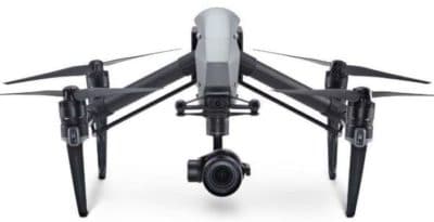
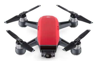
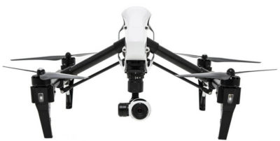
This updated DJI Inspire 1 drone review takes a close look at the features, design, gimbal and camera options on both the Inspire Standard and Professional models.

The Inspire 1 has entered new territory in drone innovation, sleek design and patented motor and gimbal engineering.  The Inspire 1 drone is very versatile with various cameras and sensors options.

In this Inspire 1 review, we take a full look at its design, intelligent flight modes, gimbals and many camera options, along with a number of top Inspire 1 videos.  We answer the many frequently asked questions such as the Inspire 1 range, distance, max height, altitude, frequency, sensors, transmission, WiFi, gimbal, camera and much more.

The DJI Inspire 1 is very close to the perfect quadcopter. The Inspire 1 allows anyone to create great aerial photography and filming shots. There are a number of cameras which can be fitted to the Inspire 1.

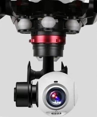
The latest camera is the Zenmuse Z3 which is the first integrated aerial zoom camera optimized for still photography. Being able to detach the gimbal on the Inspire 1 allows this drone to be used for more than just aerial filming.

For example, the Inspire 1 Pro comes with the Zenmuse X5 gimbal and 4k micro four thirds camera. This Zenmuse X5 gimbal can be removed and the new Zenmuse XT thermal imaging sensor can be attached giving the Inspire 1 real flexibility to provide solutions in many different sectors.

Fire Departments use drones to get an overall view of the area where they are battling a blaze whether it is a building or a forest.   They are also using thermal vision cameras to get information on the heat of a fire or the heat from a fire which has just been put out.

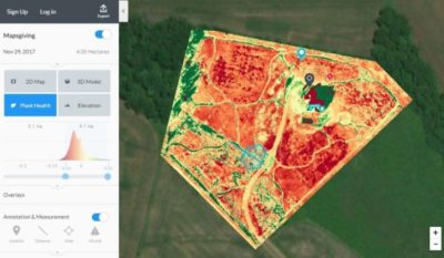
Or, how about attaching the latest Parrot Sequoia multispectral sensor for farming allowing the Inspire 1 to capture both visible and invisible images of crops, vegetation and ground cover.

The Inspire 1 is designed with adaptability in mind.

Read more

Hyperfocal Distance, Charts And APP for Aerial Photography

Understanding Hyperfocal Distance landscape photos, charts, formula and apps

Understanding hyperfocal distance will greatly enhance the quality of your landscape photography.  Here we explain everything about hyperfocal distance and how to get it right.  Then, you can practice setting the hyperfocal distance on your particular camera.

Below you will find a hyperfocal distance chart, the mathematical formula and where you can download a hyperfocal distance calculator app.  There is also some terrific hyperfocal distance photos as examples.

At the end there is also a fantastic hyperfocal distance video tutorial. 

Read more